Showing posts with label Columbia. Show all posts

Monday, September 30, 2013

Columbia University as an Agentive Landscape

The gates on Broadway.
Source: http://gs.columbia.edu/sciences-po/financing-your-education
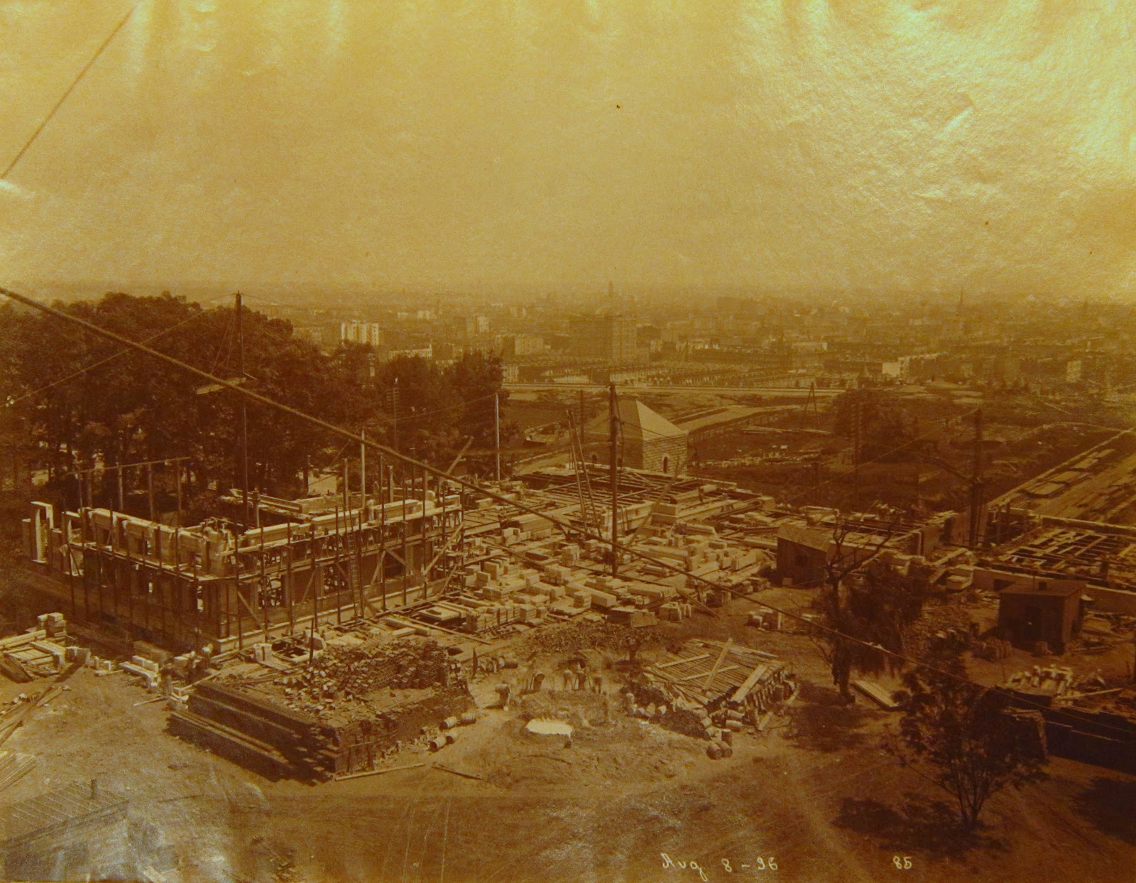
In 1896, Columbia University moved from Madison Avenue to its current campus in Morningside Heights. It occupies approximately 32 acres, which, although small for a campus, is remarkable given its location within Manhattan, famous for its limited real estate and corresponding ridiculous prices. Architecturally, with its red brick and columnar architecture, Columbia more closely resembles Harvard and other college campuses than what is typical of New York City. Even the high cost of living is mitigated to some extent; dormitories are less expensive per square foot than the surrounding apartment complexes, and some faculty have access to rent-controlled apartments near campus. These differences result in a completely different ambience within these six city blocks; the city effectively falls away. As soon as one enters the majestic gates from either Broadway or Amsterdam, the feeling of pulsating energy and grit symptomatic of New York City dissipates in favor of a calm, idyllic atmosphere removed from reality.

In his article “Material Culture after Test: Re-Membering Things,” Norwegian archaeologist Bjørnar Olsen writes, “Think how the routines, movements, and social arrangements of our daily lives are increasingly prescribed, defined and disciplined, as well as helped or encouraged, by networks of material agents. Acting increasingly imperatively, these agents tacitly demand certain behaviours, impose certain socio-spatial configurations” (2003:97). He then includes a university campus in a list of prescriptive environments. Columbia’s artificiality and controlled environment certainly support Olsen’s statement.
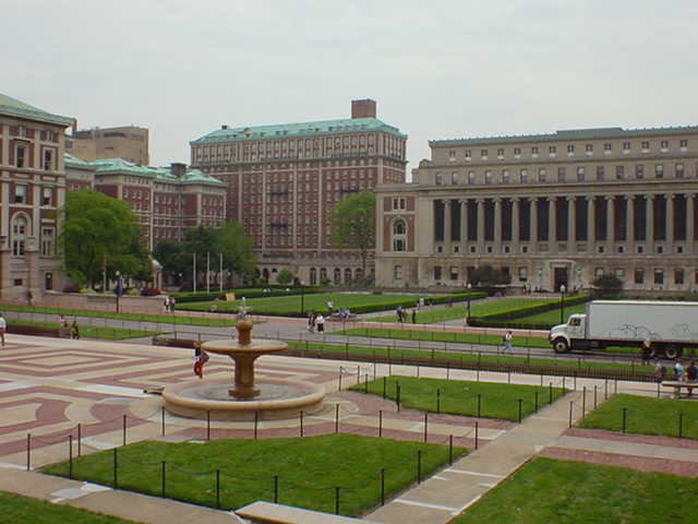
Unoccupied lawns.
Source: http://www.teslasociety.com/pbust/col3.JPG
Perhaps the most obvious example is the campus’s explicitly delineated paths, which direct movement and thus have agency to influence the university’s human population. Along with physical barricades, they often forbid people from making use of the grassy lawn areas around Columbia. When I first toured Columbia, I remember the guide drawing my attention to the extensive green space, so rare in New York City, and telling me that I would be able to read, play guitar, or just lounge about. However, since arriving this has not been the case. In a profound case of circular argument, using the grass would result in losing its embodiment of all that grass is – green, verdant, lush. Therefore, it seems as though according to the administration it is more important to SIGNIFY a lawn and its characteristics than to actually BE an active lawn space.

Another instance in which objects or, rather, collections of objects comprising spaces acquire agency at the university can be observed within the many libraries. Within each, the various rooms are assigned categories according to the degree of strictness in terms of both consumption and noise. This ranking system utilizes the same sign system as stoplights: green represents areas in which beverages can be consumed and cell phones can be used; yellow signs delineate spaces in which noise must be limited and only certain cups are allowed; and red prohibits all such activities.

Of course, many of these rules are often broken. To some extent, the degree to which violations occur corresponds to how strictly they are enforced. In other cases, though, it seems as though location also plays a role. The Nicholas Murray Butler Library, for example, the largest of Columbia’s libraries and one of the most prominent buildings on campus, technically forbids food from being brought into the library. Yet once inside, there is a café that serves not only beverages but also a variety of victuals. This evident contradiction between policy and spatial relationship has resulted in, based on my personal behavior and observations of others, excessive rule violations. While there is an area set aside for eating, many people consume food from both the library café and elsewhere in the study rooms themselves. While in other libraries I have gotten disapproving looks from other students for food consumption, in Butler there seems to be an unwritten agreement that it is acceptable to break this rule.

Butler Library.
Source: http://www.panoramio.com/photo/13082770
This minor transgression pales in comparison to other acts of dissent that have taken place on Columbia’s landscape. Butler Library was the site of student protests resulting from the 18 renowned authors and philosophers inscribed around its exterior. With the exception of one, Demosthenes, works by all of these scholars have been required reading in Columbia’s Core Curriculum. They are also, significantly, all white men. Students have used the paradigmatic association between these inscriptions and Columbia’s curriculum to raise objections to the predominantly Western male perspective of the Core, unfurling banners from the roof displaying the names of female and black writers instead. In this way, the signification and definition of the established order within the landscape affected behavior of those acting within it, not by complying with its rules but by reacting against them.

David Shapiro.
Source: http://jacketmagazine.com/37/iv-shapiro-d-ivb-kent.shtml
This negotiation between landscapes/object collectives and human actors was perhaps most dramatically played out through the famous Vietnam War protests that took place on Columbia’s campus. These defiant acts not only disrupted the university’s day to day functioning but also its projected image of beautiful but sterile symmetry and perfection. One of the most quintessential photographs from that student occupation of campus portrays David Shapiro, then a senior at Columbia College, smoking a cigar and wearing sunglasses in President Grayson L. Kirk’s office. This overt transgression of landscape parallels the attempted transgression of dominant paradigms during the 1960s.


The ROTC program at Columbia, a longstanding symbol of order and tradition, was abolished cotemporally to the Vietnam Protests. It is interesting to examine the pronounced difference in the way humans interacted with the same landscape in these situations. Columbia University is just one example of an environment that is prescribed but whose configurations can be violated, resulting in a constant dialogue between the campus and its human occupants.

Lucy Gill

Student protestors occupying Columbia.
Source: http://www.onthisdeity.com/23rd-april-1968-%E2%80%93-the-
columbia-university-student-protest/
ROTC members performing a drill.
Source: http://advocatesforrotc.org/columbia/


References:
Olsen, B. 2003. Material culture after text: Re-membering things. Norwegian Archaeological Review 36(2), 87-104. 

Friday, April 27, 2012

Excursion: Schermerhorn, the Netherlands


After having spent the semester writing about the landscape of and around Columbia University's main Campus, perhaps a little excursion to another landscape is allowed.

The Columbia Center for Archaeology is located on the 9th floor of the building Schermerhorn, which -- as we have read below -- is named after one Mr. Schermerhorn, shipping tycoon, NY society member, and descendant of Dutch settlers. But what does his -- for most English-speakers nearly unpronounceable name refer to?


View Larger Map

Mr. Schermerhorn, like many Dutch people, took his family name from a village -- in his case: the village Schermerhorn -- that his ancestors lef  at some point (presumably in the mid- to late 17th Century) to seek their good luck in the Big City. And the closest Big City near Schermerhorn is Amsterdam, about 20 miles to the south. From Amsterdam, then, the step to New Amsterdam was only a small one, certainly at this time, the founding of this colony. But why presume that Mr. Schermerhorn's ancestors left Schermerhorn in the 17th Century? First of all, most Dutch settlers of New Amsterdam (New York) settled here in that time period, but secondly: a major change took place in the landscape around Schermerhorn at this time. A change that, one can presume, had a major impact on the livelihood of inhabitants of this place.

The name Schermerhorn refers to the "horn", that is the "Corner", or "Cape" in the Schermer, which is the Holland-ified version of Frisian 'Skir Mare' or Bright Lake. In this name is sedimented a vicious series of medieval wars between the Counts of Holland and the Frisians (1272-1524), a free, self-governing people in the northern Netherlands (or a bunch of anarchic robbers, depending on your POV). Schermerhorn itself is part of West Friesland and has been firmly under Hollandic control since the late 13th Century.

Any "Bright Lake" of that name is  nowhere to be found near Schermerhorn nowadays but this showing West Friesland (or northern Holland) around 1200AD shows us where this Schermer used to be:


On the map of contemporary Schermerhorn one can see the wild and wide draining ditches of the old land, where Schermerhorn is located. These wide ditches are indices of the tragedy that was taking place in this area of Holland at this time. The old land had consisted of peaty swamp and in the Netherlands of the late middle ages peat became an increasingly popular fuel. Moreover, around this time, people discovered that one could drain the swamps that covered most of Holland, and so one could grow grain. Both processes resulted in the disappearance or lowering of land with catastrophic results. The reason that the count of Holland was finally able to subdue the Frisians here in West Friesland area was the Saint Elizabeth Flood of 1288 which resulted in a tremendous loss of land and life as the sea took the land that the inhabitants had destroyed. And the lakes that had been created by the 'mining' of peat from the swamp had already started growing on their own. When storms came, the lake's waves literally started eating on the edges of the land and so the once small lakes of Beemster, Schermer, Purmer, Wormer, and Haarlemmer became bigger and bigger and bigger, destroying lands and homes and villages. This process was referred to as the Water Wolf. As you can see above, Schermerhorn was very close to the edge of the water: the Water Wolf almost got to it. Maybe the Schermerhorners had adjusted and became fishermen: for instance, eel was a common fish in these parts and remains popular.

Attack of the Water Wolf
However, just after having recovered from the assaults of War and Water, rich Amsterdam gentlemen came and drained the lakes. First, in 1612, they drained the Beemster, just east of Schermerhorn, and then the Schermer,  just to the west, in 1635. This new land is clearly visible in the landscape: the small, narrow draining ditches of the new land (mostly clay and therefore needing less drainage) contrast strongly with wild and wides ditches of the old land, which was a water-soaked, swampy peat. These Amsterdam gentlemen, investors in a private company, then divided up among themselves the newly created land and they built their rational, grid pattern, renaissance era farms on it. These patterns have been so well preserved that the Dutch government has made these "droogmakerijen" UNESCO World Heritage Sites. But what about the inhabitants of Schermerhorn? Maybe, as former fishermen, they sought their luck at sea and they sailed to faraway places in East and West. Or maybe they went looking for a plot of land, or a craft, any craft, elsewhere. Clearly, at some point, some came to New Amsterdam and eventually they became gentlemen themselves.

Wednesday, April 25, 2012

An Oasis in New York City

When I first told my father I was considering applying to Columbia University, he told me that the campus was like an oasis.  He said that you walk from the busy city in through the gates of the campus, and it was quiet and green and beautiful.  Since then, I've heard many other people describe Columbia's campus this way, including in this class and in these blog posts.  Other posts have mentioned its situation atop a hill, its classical architecture, its exclusionary exterior, its elegant brick work, and so on.  And so I was quite surprised to find, in my research on Columbia's associated neighbor, Barnard College, that in fact, across the street from Columbia had once been comparably far lusher than Columbia.

Barnard College was founded in 1889 and began a rented brownstone downtown by Columbia's original location.  In 1896, a few years after Columbia moved up to Morningside Heights, Barnard followed it uptown and moved to a small, one acre plot directly across Broadway (Barnard Archives: "Chronology"). Maps of Barnard College are included in the maps of the Columbia University campus, published annually in the Columbia University Catalogue.  Below is a map from 1898, which depicted Barnard's initial campus, consisting of three inter-connected buildings on the block between 119th and 120th streets.


Courtesy of the Columbia University Archives


The three buildings were known as Fisk, Milbank, and Brinkerhoff Halls, although now all three are referred to as Milbank Hall.  Below is a sketch of the buildings and their exterior courtyard from circa 1898.  As you can see in the sketch, the building emulates the classical influences Columbia is known for, as well as the red brick and ivy-covered facade.

Taken from the publication, "Barnard College, New York City, Plans of the new building on the Boulevard at One-hundred and nineteenth Street", published by Barnard College.  Courtesy of the Barnard College Archives.

Even then, Barnard and Columbia were closely affiliated as they are now.  The publication cited in the caption above states that fourth year Barnard women could take classes at Columbia.  In addition, Barnard students had full use of the Columbia library, and so Milbank contained only a reading room and reference desk.

Several years later, in 1907, Brooks Hall was completed, and was a student dormitory. It capped the bottom of the present Barnard campus. Although 119th street cut between the Milbank complex and the rest of the Barnard campus until the 1960s, the current campus still runs between Brooks and Milbank, and has not expanded.  Dormitories have been built or acquired outside the campus in the Morningside Heights neighborhood in order to house the present student population, but the campus itself has remained the same size.  Below is a map of Barnard's campus in 1910.  In the maps, you can see the plan of paths and tennis courts, as well as the buildings.  In addition, the squares and lines around the outside of the bulk of campus represent an iron fence.  Like Columbia, as has been discussed in previous blog posts, Barnard restricted entry to its campus from early on.  Also below is a photograph of campus at that time.


Courtesy of Columbia University Archives


Courtesy of the Barnard College Archives


The wooded area by the tennis courts was known as "The Jungle," and in my opinion epitomizes the 'oasis' ideal, often associated with Columbia.  This verdant landscape contained numerous types of trees, winding paths, benches, etc.  Below is an aerial view of "The Jungle," taken during the 1950s.  Also below is a circa 1950 image of two Barnard students in the "Jungle" area of campus, which appears quite idyllic. 
Courtesy of the Barnard College Archives
Aerial view of the Jungle, looking north, circa 1950s.
Courtesy of the Barnard College Archives
         
By this time, a third building existed on campus, then known as Students' Hall, and now called Barnard Hall. The layout of the campus is on the left part of the image below, the layout of Barnard's campus is visible next to its larger neighbor.  As you can see, by this point in time much of Columbia's campus had been developed, although 116th street was still open to traffic, and the southern part of campus was still open at the bottom. 

Map from 1918, Courtesy of the Columbia University Archives

Student's Hall was followed shortly by an entrance gate, first labeled on the maps in the 1924-1925 Columbia Directory.  The picture below shows the "Helen Hartley Jenkins Geer Memorial Gate," or the "Geer Gate," which still stands at Barnard's main entrance today.  Behind it is the ivy covered Students' Hall.  Even though this is the most built-up part of Barnard's campus at this time, it still gives the impression of gates enclosing a garden.

Geer Gate ca. 1944. Photograph by Paul Parker, courtesy of the Barnard College Archives.
Although during the 1950s, several more buildings were added to the southern part of campus, adjoining Brooks, the Jungle and tennis courts remained intact until the 1960s, when the Lehman Library was built.  Little by little, Barnard began to follow in Columbia's footsteps of filling its borders with buildings and shutting out the rest of the city.  In the below picture, depicting the view of Brooks, Reid, and Hewitt along 116th street (just outside the southern edge of campus), Barnard has adopted Columbia's pattern of giving outside viewers a cold image of the backs of buildings.

Courtesy of the Barnard College Archives
Today, while Barnard's campus still has some green space, nearly all of its borders are filled by buildings.  I might still consider it to be somewhat of a miniature oasis, but after looking at the stunning pictures of the "Jungle," I realize that it is not even close to its former natural beauty.  Like Columbia, Barnard was pressured by space constraints and an increasing student body, requiring additional facilities. Barnard's predominantly classical architecture, imposing iron gates, and ivy covered brick match the style of Columbia's campus, linking the two together aesthetically.  In its early stages, Barnard only blocked off the city around it to the north, south, and west, leaving open its side facing Columbia, but in the last 30 years it has blocked off its western side as well.  Perhaps this is significant, relating to Barnard and Columbia's relationship over time.  The recent onslaught of negative online comments highlights the present tension between the schools, particularly since Columbia became co-ed, forcing new definitions and purposes for each.  Interestingly, Columbia became co-ed only 5 years before Barnard constructed Centennial Hall (now Sulzberger Hall), the first building to majorly obstruct the site lines from Columbia into Barnard, further closing the eastern side of campus. Perhaps Barnard's closing off of itself from Columbia is defensive- it is claiming its right to remain an independently run but affiliated institution for women, even though it is no longer the sole educator of women in the University.

Sources:
Barnard College Archives
Columbia University Archives- Buildings and Grounds Collection

Barnard College Archives. Chronology. <http://barnard.edu/archives/history/chronology>

Barnard College Archives. History of the College. <http://barnard.edu/archives/history>

Barnard College. 1989 (?) Barnard College, New York City, Plans of the new building on the                         Boulevard at One-hundred and nineteenth Street. Pamphlet, published by Barnard College.

Schermerhorn Hall Past & Present

It isn't surprising, really, that people have a tendency to ignore the changes that have happened in the spaces closest to them - physical objects have a way of asserting themselves as so concrete that it's easy to forget that their permanence is just an illusion.  I realized that after learning so much about the landscape of Columbia University and the surrounding areas over the course of the semester that I knew very little about the part of Columbia that I've spent the most time in - Schermerhorn Hall.  As I delved into the archives related to this building, the home of the anthropology department (and many others) since it was built, I uncovered a surprisingly shifting past, full of change and innovation almost from the start.

Schermerhorn Hall came into being in 1895, as the result of a donation from William C. Schermerhorn, chairman of the university's Board of Trustees at the time.  Descended from the city's original Dutch settlers who eventually became shipping tycoons, Mr. Schermerhorn was a Columbia College alumni (class of 1840) who also served on the boards of the American Museum of Natural History and the Metropolitan Museum of Art.  The building was designed by the firm of McKim, Mead, & White, the same architects of Low Library and many other campus buildings, and construction began on the foundation and lower levels later that year, with the official dedication and cornerstone ceremony being held on May 2, 1896, presided over by President Low, with Mr. Schermerhorn and many others in attendance (picture below).


Construction progressed rapidly over the course of that year and the building was ready for use by the beginning of the fall semester of 1897.  As can be seen in one of the pictures, Fayerweather Hall was built simultaneously right next door, the original home of the Pupin Physics Laboratory, which later moved into its own building.  Dedicated for the use of the "natural sciences," Schermerhorn Hall played host to many departments in its early years (many of which no longer exist), including anthropolgy, zoology, botany, mineralogy, geology, and biology.  The original ground floor entrance hall, which included a sweeping staircase and open vestibule (seen below), existed until the main building's first major renovation in 1946.


 The lower levels were primarily devoted to museum and lab space for the geology and mineralogy departments while the remaining departments competed for space in the floors above.  The crowding became so acute over the ensuing decades that the university was forced to add the Schermerhorn Extension, funded by a $1 million donation from the original Mr. Schermerhorn's nephew, F. August Schermerhorn (class of 1868).  The building was also designed by McKim, Mead, & White, and was complete by the beginning of Fall 1929.  As can be seen in the original plans below, even the simple floorplan of the extension has been adapted over time.  963 Schermerhorn, the present location of our classroom, was then 962, which included two storage closets and a door into an adjoining lab.
 
 
Even with the addition of the Extension, complaints of crowding in Schermerhorn continued unabated over most of the 20th century.  Beginning in 1940, crowding in the main building was exacerbated by the takeover of the 200 and 300 levels by the university to give Enrico Fermi and his team more lab space to work on the Manhattan Project to build the first atomic bomb.  The federal government gave Columbia $900,000 in 1946 to restore those two floors, which the university also used to demolish the original central staircases in favor of an elevator.  Below we can see an evolution of the building's exterior in pictures, which changed quite dramatically in 1912 with the additional of the Avery Library.
 A lighthearted, but telling, New York Times story from 1948 illustrated the crowding, telling of a mishap in Schermerhorn in which about two dozen of the biology department's frogs escaped from their tanks and took up residence in the adjoining psychology department library.  In 1969, quite a scandal ensued after three department chairmen (psychology, art history, and geology) all resigned in protest of Schermerhorn's overcrowded conditions after complaints of the severe overcrowding continued to go unaddressed by the university.  According to the article, the art history department at that time was squeezing five individuals to an office for lack of space.  Eventually, as departments dissolved or moved into new buildings of their own, the issue of overcrowding lessened.  Though it is one of the campus' original 19th century structures, Schermerhorn Hall has certainly adapted and grown with the years, leading me to wonder what the future holds for this venerable old building.

Wednesday, April 18, 2012

Columbia and Union Theological Seminary

As a graduate of a divinity school, I am fascinated by the relationship that theological institutions have with the larger universities with which they are often associated. With this interest in mind, I sought to examine the history of Union Theological Seminary, with a special emphasis on its relationship with Columbia. What I found was that the Seminary, at the time of its relocation to Morningside Heights in the early 20th century, simultaneously became part of the larger university community while distinguishing itself as an independent entity in various ways. This dual character is embodied by the location of the space and its architectural style.

(Union Theological Seminary, Park Ave. Campus, 1884)

In 1884, a new campus was constructed at 700 Park Avenue to house the seminary; after only 20 years, the campus was deemed inadequate for various reasons, and plans for the construction of a new campus were drawn up. This relocation was made possible in large part by a donation of 1.6 million dollars made by the vice president of the board of trustees, and construction commenced in 1908.

(The Seminary Under Construction)

In a paper, written in 1986, entitled “Union,” Mirande E. Dupuy details the circumstances and process of this construction. She notes that according to the initial design requirements of the Building and Site Committee, the site was to be conceived as a space “of Instruction and Administration, of Worship and Residence” and as “an institution of higher learning made distinctive by religious rather than purely academic motive.” Additionally, the committee called for the proposed site to be architecturally consonant with surrounding academic institutions (ie Barnard, Columbia and the Teacher’s College) “so as to promote a harmonious ensemble.” At the same time, the campus was to “have such individuality of treatment as to make evident [its] organic distinctiveness and peculiar character.” This tension – between its simultaneous inclusion in the university community and distinctiveness from it – manifested itself in other ways as well.

According to a timeline on the Union Theological Seminary Website, in March 1903, the seminary trustees received a letter from the trustees of Columbia which expressed “their great satisfaction that the Seminary had secured a site near the University grounds” and which offered “the literary advantages of our college to the Seminary students.” On the other hand, as Dupuy notes, in an article in the New York Times which appeared in 1905, the president of the seminary, Charles Cuthbert Hall, “was emphatic in his statement that the identities of the institutions would not change” and that the seminary “would not relinquish its ‘corporate independence.’” The quote is a telling one, as it suggests that Hall found it necessary to affirm the seminary’s autonomy from Columbia University, the status of which might have been seen as vulnerable given the location of the new site.

The firm chosen to design the new campus was Allen and Collins; their design reflects the manner in which the UTS campus is visually distinct from that of Columbia. Dupuy points out that the plan was influenced by the prevalence of the “High Gothic Revival” in architecture during the early 20th century. This revival was perhaps inaugurated by the church architect Ralph Adams Cram (who, incidentally, designed St. John the Divine). She goes on to describe the movement as being defined by “a need to return to the monastic intensity of purposeful learning as there had been in the quadrangles of the medieval colleges.” The Union campus was directly influenced by the Cambridge University. The campus, closed off in a separate quadrangle, with its very different architectural style as compared to McKim, Mead and White’s Columbia, thus accomplished the task of distinguishing the space stylistically and spatially from other parts of campus. Perhaps the choice of this specific style, popularized by a church architect, was particularly conducive to the role of UTS as a religious and an academic space.

It is interesting to note that the Seminary quadrangle today is not as closed off from the rest of the Columbia Campus as it was once. 80 Claremont Ave., at its southwest end, houses the University's Religion department; Knox Hall, at its northwest end, houses the departments of Sociology and Middle Eastern, South Asian and African Studies. Reflecting on the relationship between Union and Columbia, one in which these two institutions are interdependent yet distinct, leads me to wonder how the University has related to the other educational institutions in Morningside Heights.

(Dupuy paper courtesy of Columbia University Archives, Buildings and Grounds Collection; Images Courtesy of New York Public Library Digital Gallery)

-Jay Ramesh

Tuesday, April 17, 2012

College Walk and the Acropolis of America

Since visiting the archives, my mind has continually been drawn back to the description of Columbia as the “acropolis of America.” This phrase is perhaps over enthusiastic (the acropolis of America? Not an acropolis-- the acropolis!) but nonetheless it has resonated with me and I think about it often as I wander about the campus. Having been to the Acropolis and many other ancient Roman or Greek places of discourse, scholarship and culture, I want to explore the ways in which Columbia’s campus compares this model. Most of us traverse College Walk at least once a day, and so it’s there I would like to focus.

As we are now well aware, Columbia’s campus was not designed with the south lawn in mind. Low was supposed to look down on the city. Yet, as we are again well aware, Butler and the other buildings of the southern campus were built, thus transforming campus into a box. But it wasn’t always a box-- until the early 20th century, 116th street continued directly through campus as an active motorway. Cars zipped past (undoubtedly dodging graduate students who meandered in the street fascinated by springtime sunlight, like children in a toy store) cars parked, people waited to cross the street, people looked both ways before doing so. Now, it is different. You could essentially cartwheel across College Walk with no real threat of being run over, and the old road’s median has become a lounge.


It is curious to me, in a way, that the notion of Columbia as being the “Acropolis of America” originated closer to the time that College Walk was a road than the time it was not. As Dolkart showed in his writings, Columbia’s campus was designed with ancient Greece and Rome in mind. In modern times, this illusion comes across strongly-- campus IS secluded, a little intellectual island in the midst of the city. But having an active motorway rip through the center of campus-- right between the Pantheon and a Greek-fascaded library-- would have a profound impact on this idea of Columbia as an intellectual forum in the style of the ancients. When I see photos like the one I’ve posted in this entry, campus seems immediately different: more included in the city, but separate from the design that had been intended for it.

The closure of the 116th street motorway through campus seems to me a major transition point in the landscape of Columbia’s campus. It didn’t change a whole lot physically, but that closure changed the ways in which we perceive that space and, resultingly, in how the north and south campuses are tied together into the unit we consider “campus.” Instead of two halves bisected by the outside world, Columbia is now an acropolis of sorts-- a sort of secluded place of cultural and intellectual exchange unimpinged by outside influences.

Photo credit: Columbia University Archives

Monday, April 16, 2012

The Most Dangerous Place in the Most Dangerous City


Last year, the local Columbia University press began to report on gun shootings taking place in Morningside Park, in addition to an increase in overall crime in the park. (Leland, 2011; Vigeland, 2011; Lopez, 2011)  Even the New York Times commented on the crimes, which shocked a neighborhood known for its extensive restoration of the area. (Leland, 2011)  Parents openly spoke to reporters about the pressure they felt to leave for the suburbs, and neighbors put pressure on the New York City police to patrol Morningside Park and make arrests. (Leland, 2011)  People raising children in million-dollar brownstones along the Park’s main boulevard expressed fear of enjoying its nearby playgrounds, ball courts, and pathways. (Leland, 2011) Most notable, however, was the immediate response of the city authorities in what seemed like a speech from a long-gone era:  that when crime happens in an area where “everyone knows crime happens,” such as a Harlem park, a basketball court filled with teenagers, or an area where drugs may be sold,  people should feel pressure to despair and let events take their course, as if city landscapes somehow have an immoveable identity produced by some heavy historical force, the weight of the past directing events which take place today, which cannot be altered. (Leland, 2011) 

Morningside Park 01.jpg
Morningside Park ball fields.

While the subsequent response of local Morningside Park residents was immediate and successful in attracting assistance to their plight, the experience and the interest it generated for them highlighted the precarious nature of their neighborhood. (Leland, 2011; Vigeland, 2011; Lopez, 2011)  Morningside Park is hallowed and, in many ways, haunted ground in the Columbia University and Harlem area because of its history, and for the lingering memory it holds of an old New York City landscape which is still in the process of passing away.   

Morningside Park is famous, first and foremost, among Columbia neighborhood residents as the contested site of a gym which the university proposed to build in 1968 under circumstances which the community and its own students found unacceptable.  Dramatic public protests and students occupations of campus buildings erupted and led to the reorganization of university life. (www.Columbia1968.com)  However, Morningside Park has a second identity which was representative at the time of the city as a whole:  as a dangerous wasteland of romanticized urban decay.  This emblematic degradation was viewed as if it had always existed, both as some reflection of an existential state of mind which was projected on the world as a criminalized landscape, and as the result of elitist public policy which, through some undefined natural law, could somehow never extend to the residents of certain areas such as black Harlem because of an intrinsic flaw in the municipal system's identity.  

In the reality of the 1970s through the 1990s, Morningside Park itself was so dangerous that everyone near it was warned never to set foot in it at any time of the day or night. (Leland, 2011)  Drug dealers, homeless alcoholics, and criminals hid in the park's trees and cliff face caves, waiting to attack any wandering student or child who ventured near them.  Gangs pulverized whatever remaining markers of civilization were left standing.  From outside its grassy borders or from high terraces overlooking its paths, the innocent people of the neighborhood or tourists hoping to see the most dangerous spots in the city could peer inside and attempt to observe the guilty, a raggedy group of New Yorkers who could easily be stand-ins for every victim of Wall Street’s financial boom.  New York City seemed, from the outside, simultaneously like a preserve for the unstoppably successful and the hopelessly lost and left behind—and like a stray wanderer in the wrong park, any New Yorker could find him or herself on either path with one wrong step.  As a result, places like Morningside Park held a thrill of fear and fascination, because whatever urban force had made them so dangerous could not be contained and might spill over into the streets at any moment.  The park, and also the New York landscape which surrounded it, suggested that modern civilization had some elemental thanatos, a drive to self-destruct, as its inevitable companion.  For those who could not find a safe path through life in time, there might be a fall through every safety net of urban civilization to some dark lower region where one’s choices were limited to perpetrator, victim, or helpless bystander.  This process seemed to affect so many people in New York at that time, when the city was famed for its violence and trashy grittiness, that it assumed a self-perpetuating epic quality.

Morningside Park pathways.

This epic quality can still be seen in many contemporary discussions of racial tensions surrounding Morningside Park’s history, especially surrounding the Columbia gym and its impact on the neighborhood’s collective memory.  Although many years have passed since the student protests of Morningside Park, the story of those events still brings up strong emotions regarding racism, city politics, and the tensions between rich and poor New York residents.  This suggests not only that certain problems may still exist in the community, but also that the protest events of 1968 can still be seen as a backdrop for an ongoing battle between light and dark social forces.  Morningside Park certainly lends itself to such a staging, as its forested paths are attached to a cliff face that visibly separates a wealthy area that is primarily white and educated from an area that is primarily black with a mixed economic constituency.  

The cliff face divide between Columbia University and Harlem.

At first glance, logic would suggest that people produce landscapes.  Artists and philosophers may argue over the mythic qualities of an area as if it was representative of some eternal idea, but when public policy is put in place, neighborhoods change, and suddenly the disputed, seemingly unchangeable landscape fades from view.  Or the opposite may occur:  people may militate for a change in policy to alter an urban landscape as if this were easy, even as that landscape is generating obstacles to change that override all their efforts, as if it had a life of its own.  Over the past ten years, the Morningside Park neighborhood has seen median home prices triple, and median family incomes have risen 48 percent.  (Leland, 2011)  Yet the recent shootings in Morningside Park sent a chill through the community, as if its middle-class success was still, in people's minds, holding back some inevitable tide of violence that could sweep back over the neighborhood at any time.  In a white, educated neighborhood, it would be the violence, not the middle-class success story, that would likely be the anomaly.

Morningside Park brownstones in Harlem.

Are people a part of their landscapes, like the tiny villagers who populate medieval paintings of pastoral farmland, or do they create landscapes as agents of civilization, which makes civilized landscapes the responsibility of their creators?  And is civilization’s progress a force of creation or destruction?  These questions can paralyze people from taking actions that seem simple, such as mobilizing with a sense of entitlement to stop crime in a black neighborhood, or lead them to preserve what might be better off replaced, such as the ungentrified neighborhoods of old New York City, whose local color included public spaces that resembled war zones.   Few would suggest that Morningside Park be abandoned to crime again in order to spark a debate on the social inequalities of New York, or to expose the city’s lurking Wall Street-driven decay.  Yet people still point to it as a boundary between the rich and the poor, not between millionaire black and white homeowners, and the initial reaction residents met after the recent shootings in the park demonstrates there is still a lingering fear of shifting the landscape, once and for all, to one of integration, safety, and success.


References


City of New York Parks and Recreation Department.  http://www.nycgovparks.org/parks/morningsidepark 

Friends of Morningside Park.  http://morningsidepark.org/ 

Leland, John.  “A Summer Idyll, and Then Three Bullets.”  The New York Times, Aug. 12, 2011: New York City/Region.   http://www.nytimes.com/2011/08/14/nyregion/shooting-in-morningside-park-tests-harlems-bond-with-past.html?pagewanted=all 

Lopez, Lolita.  “Frightened Harlem Residents Avoid Morningside Park.”  Pix11.com, July 12, 2011.  http://www.wpix.com/news/wpix-morningside-park-shootings,0,7700292.story

Vigeland, Finn. “Community forums address violence in Morningside Park.”  The Columbia Spectator, Aug. 16, 2011: Spectrum.  http://spectrum.columbiaspectator.com/spectrum/community-forums-address-violence-morningside-park