Friday, April 27, 2012

Excursion: Schermerhorn, the Netherlands


After having spent the semester writing about the landscape of and around Columbia University's main Campus, perhaps a little excursion to another landscape is allowed.

The Columbia Center for Archaeology is located on the 9th floor of the building Schermerhorn, which -- as we have read below -- is named after one Mr. Schermerhorn, shipping tycoon, NY society member, and descendant of Dutch settlers. But what does his -- for most English-speakers nearly unpronounceable name refer to?


View Larger Map

Mr. Schermerhorn, like many Dutch people, took his family name from a village -- in his case: the village Schermerhorn -- that his ancestors lef  at some point (presumably in the mid- to late 17th Century) to seek their good luck in the Big City. And the closest Big City near Schermerhorn is Amsterdam, about 20 miles to the south. From Amsterdam, then, the step to New Amsterdam was only a small one, certainly at this time, the founding of this colony. But why presume that Mr. Schermerhorn's ancestors left Schermerhorn in the 17th Century? First of all, most Dutch settlers of New Amsterdam (New York) settled here in that time period, but secondly: a major change took place in the landscape around Schermerhorn at this time. A change that, one can presume, had a major impact on the livelihood of inhabitants of this place.

The name Schermerhorn refers to the "horn", that is the "Corner", or "Cape" in the Schermer, which is the Holland-ified version of Frisian 'Skir Mare' or Bright Lake. In this name is sedimented a vicious series of medieval wars between the Counts of Holland and the Frisians (1272-1524), a free, self-governing people in the northern Netherlands (or a bunch of anarchic robbers, depending on your POV). Schermerhorn itself is part of West Friesland and has been firmly under Hollandic control since the late 13th Century.

Any "Bright Lake" of that name is  nowhere to be found near Schermerhorn nowadays but this showing West Friesland (or northern Holland) around 1200AD shows us where this Schermer used to be:


On the map of contemporary Schermerhorn one can see the wild and wide draining ditches of the old land, where Schermerhorn is located. These wide ditches are indices of the tragedy that was taking place in this area of Holland at this time. The old land had consisted of peaty swamp and in the Netherlands of the late middle ages peat became an increasingly popular fuel. Moreover, around this time, people discovered that one could drain the swamps that covered most of Holland, and so one could grow grain. Both processes resulted in the disappearance or lowering of land with catastrophic results. The reason that the count of Holland was finally able to subdue the Frisians here in West Friesland area was the Saint Elizabeth Flood of 1288 which resulted in a tremendous loss of land and life as the sea took the land that the inhabitants had destroyed. And the lakes that had been created by the 'mining' of peat from the swamp had already started growing on their own. When storms came, the lake's waves literally started eating on the edges of the land and so the once small lakes of Beemster, Schermer, Purmer, Wormer, and Haarlemmer became bigger and bigger and bigger, destroying lands and homes and villages. This process was referred to as the Water Wolf. As you can see above, Schermerhorn was very close to the edge of the water: the Water Wolf almost got to it. Maybe the Schermerhorners had adjusted and became fishermen: for instance, eel was a common fish in these parts and remains popular.

Attack of the Water Wolf
However, just after having recovered from the assaults of War and Water, rich Amsterdam gentlemen came and drained the lakes. First, in 1612, they drained the Beemster, just east of Schermerhorn, and then the Schermer,  just to the west, in 1635. This new land is clearly visible in the landscape: the small, narrow draining ditches of the new land (mostly clay and therefore needing less drainage) contrast strongly with wild and wides ditches of the old land, which was a water-soaked, swampy peat. These Amsterdam gentlemen, investors in a private company, then divided up among themselves the newly created land and they built their rational, grid pattern, renaissance era farms on it. These patterns have been so well preserved that the Dutch government has made these "droogmakerijen" UNESCO World Heritage Sites. But what about the inhabitants of Schermerhorn? Maybe, as former fishermen, they sought their luck at sea and they sailed to faraway places in East and West. Or maybe they went looking for a plot of land, or a craft, any craft, elsewhere. Clearly, at some point, some came to New Amsterdam and eventually they became gentlemen themselves.

Wednesday, April 25, 2012

An Oasis in New York City

When I first told my father I was considering applying to Columbia University, he told me that the campus was like an oasis.  He said that you walk from the busy city in through the gates of the campus, and it was quiet and green and beautiful.  Since then, I've heard many other people describe Columbia's campus this way, including in this class and in these blog posts.  Other posts have mentioned its situation atop a hill, its classical architecture, its exclusionary exterior, its elegant brick work, and so on.  And so I was quite surprised to find, in my research on Columbia's associated neighbor, Barnard College, that in fact, across the street from Columbia had once been comparably far lusher than Columbia.

Barnard College was founded in 1889 and began a rented brownstone downtown by Columbia's original location.  In 1896, a few years after Columbia moved up to Morningside Heights, Barnard followed it uptown and moved to a small, one acre plot directly across Broadway (Barnard Archives: "Chronology"). Maps of Barnard College are included in the maps of the Columbia University campus, published annually in the Columbia University Catalogue.  Below is a map from 1898, which depicted Barnard's initial campus, consisting of three inter-connected buildings on the block between 119th and 120th streets.


Courtesy of the Columbia University Archives


The three buildings were known as Fisk, Milbank, and Brinkerhoff Halls, although now all three are referred to as Milbank Hall.  Below is a sketch of the buildings and their exterior courtyard from circa 1898.  As you can see in the sketch, the building emulates the classical influences Columbia is known for, as well as the red brick and ivy-covered facade.

Taken from the publication, "Barnard College, New York City, Plans of the new building on the Boulevard at One-hundred and nineteenth Street", published by Barnard College.  Courtesy of the Barnard College Archives.

Even then, Barnard and Columbia were closely affiliated as they are now.  The publication cited in the caption above states that fourth year Barnard women could take classes at Columbia.  In addition, Barnard students had full use of the Columbia library, and so Milbank contained only a reading room and reference desk.

Several years later, in 1907, Brooks Hall was completed, and was a student dormitory. It capped the bottom of the present Barnard campus. Although 119th street cut between the Milbank complex and the rest of the Barnard campus until the 1960s, the current campus still runs between Brooks and Milbank, and has not expanded.  Dormitories have been built or acquired outside the campus in the Morningside Heights neighborhood in order to house the present student population, but the campus itself has remained the same size.  Below is a map of Barnard's campus in 1910.  In the maps, you can see the plan of paths and tennis courts, as well as the buildings.  In addition, the squares and lines around the outside of the bulk of campus represent an iron fence.  Like Columbia, as has been discussed in previous blog posts, Barnard restricted entry to its campus from early on.  Also below is a photograph of campus at that time.


Courtesy of Columbia University Archives


Courtesy of the Barnard College Archives


The wooded area by the tennis courts was known as "The Jungle," and in my opinion epitomizes the 'oasis' ideal, often associated with Columbia.  This verdant landscape contained numerous types of trees, winding paths, benches, etc.  Below is an aerial view of "The Jungle," taken during the 1950s.  Also below is a circa 1950 image of two Barnard students in the "Jungle" area of campus, which appears quite idyllic. 
Courtesy of the Barnard College Archives
Aerial view of the Jungle, looking north, circa 1950s.
Courtesy of the Barnard College Archives
         
By this time, a third building existed on campus, then known as Students' Hall, and now called Barnard Hall. The layout of the campus is on the left part of the image below, the layout of Barnard's campus is visible next to its larger neighbor.  As you can see, by this point in time much of Columbia's campus had been developed, although 116th street was still open to traffic, and the southern part of campus was still open at the bottom. 

Map from 1918, Courtesy of the Columbia University Archives

Student's Hall was followed shortly by an entrance gate, first labeled on the maps in the 1924-1925 Columbia Directory.  The picture below shows the "Helen Hartley Jenkins Geer Memorial Gate," or the "Geer Gate," which still stands at Barnard's main entrance today.  Behind it is the ivy covered Students' Hall.  Even though this is the most built-up part of Barnard's campus at this time, it still gives the impression of gates enclosing a garden.

Geer Gate ca. 1944. Photograph by Paul Parker, courtesy of the Barnard College Archives.
Although during the 1950s, several more buildings were added to the southern part of campus, adjoining Brooks, the Jungle and tennis courts remained intact until the 1960s, when the Lehman Library was built.  Little by little, Barnard began to follow in Columbia's footsteps of filling its borders with buildings and shutting out the rest of the city.  In the below picture, depicting the view of Brooks, Reid, and Hewitt along 116th street (just outside the southern edge of campus), Barnard has adopted Columbia's pattern of giving outside viewers a cold image of the backs of buildings.

Courtesy of the Barnard College Archives
Today, while Barnard's campus still has some green space, nearly all of its borders are filled by buildings.  I might still consider it to be somewhat of a miniature oasis, but after looking at the stunning pictures of the "Jungle," I realize that it is not even close to its former natural beauty.  Like Columbia, Barnard was pressured by space constraints and an increasing student body, requiring additional facilities. Barnard's predominantly classical architecture, imposing iron gates, and ivy covered brick match the style of Columbia's campus, linking the two together aesthetically.  In its early stages, Barnard only blocked off the city around it to the north, south, and west, leaving open its side facing Columbia, but in the last 30 years it has blocked off its western side as well.  Perhaps this is significant, relating to Barnard and Columbia's relationship over time.  The recent onslaught of negative online comments highlights the present tension between the schools, particularly since Columbia became co-ed, forcing new definitions and purposes for each.  Interestingly, Columbia became co-ed only 5 years before Barnard constructed Centennial Hall (now Sulzberger Hall), the first building to majorly obstruct the site lines from Columbia into Barnard, further closing the eastern side of campus. Perhaps Barnard's closing off of itself from Columbia is defensive- it is claiming its right to remain an independently run but affiliated institution for women, even though it is no longer the sole educator of women in the University.

Sources:
Barnard College Archives
Columbia University Archives- Buildings and Grounds Collection

Barnard College Archives. Chronology. <http://barnard.edu/archives/history/chronology>

Barnard College Archives. History of the College. <http://barnard.edu/archives/history>

Barnard College. 1989 (?) Barnard College, New York City, Plans of the new building on the                         Boulevard at One-hundred and nineteenth Street. Pamphlet, published by Barnard College.

Schermerhorn Hall Past & Present

It isn't surprising, really, that people have a tendency to ignore the changes that have happened in the spaces closest to them - physical objects have a way of asserting themselves as so concrete that it's easy to forget that their permanence is just an illusion.  I realized that after learning so much about the landscape of Columbia University and the surrounding areas over the course of the semester that I knew very little about the part of Columbia that I've spent the most time in - Schermerhorn Hall.  As I delved into the archives related to this building, the home of the anthropology department (and many others) since it was built, I uncovered a surprisingly shifting past, full of change and innovation almost from the start.

Schermerhorn Hall came into being in 1895, as the result of a donation from William C. Schermerhorn, chairman of the university's Board of Trustees at the time.  Descended from the city's original Dutch settlers who eventually became shipping tycoons, Mr. Schermerhorn was a Columbia College alumni (class of 1840) who also served on the boards of the American Museum of Natural History and the Metropolitan Museum of Art.  The building was designed by the firm of McKim, Mead, & White, the same architects of Low Library and many other campus buildings, and construction began on the foundation and lower levels later that year, with the official dedication and cornerstone ceremony being held on May 2, 1896, presided over by President Low, with Mr. Schermerhorn and many others in attendance (picture below).


Construction progressed rapidly over the course of that year and the building was ready for use by the beginning of the fall semester of 1897.  As can be seen in one of the pictures, Fayerweather Hall was built simultaneously right next door, the original home of the Pupin Physics Laboratory, which later moved into its own building.  Dedicated for the use of the "natural sciences," Schermerhorn Hall played host to many departments in its early years (many of which no longer exist), including anthropolgy, zoology, botany, mineralogy, geology, and biology.  The original ground floor entrance hall, which included a sweeping staircase and open vestibule (seen below), existed until the main building's first major renovation in 1946.


 The lower levels were primarily devoted to museum and lab space for the geology and mineralogy departments while the remaining departments competed for space in the floors above.  The crowding became so acute over the ensuing decades that the university was forced to add the Schermerhorn Extension, funded by a $1 million donation from the original Mr. Schermerhorn's nephew, F. August Schermerhorn (class of 1868).  The building was also designed by McKim, Mead, & White, and was complete by the beginning of Fall 1929.  As can be seen in the original plans below, even the simple floorplan of the extension has been adapted over time.  963 Schermerhorn, the present location of our classroom, was then 962, which included two storage closets and a door into an adjoining lab.
 
 
Even with the addition of the Extension, complaints of crowding in Schermerhorn continued unabated over most of the 20th century.  Beginning in 1940, crowding in the main building was exacerbated by the takeover of the 200 and 300 levels by the university to give Enrico Fermi and his team more lab space to work on the Manhattan Project to build the first atomic bomb.  The federal government gave Columbia $900,000 in 1946 to restore those two floors, which the university also used to demolish the original central staircases in favor of an elevator.  Below we can see an evolution of the building's exterior in pictures, which changed quite dramatically in 1912 with the additional of the Avery Library.
 A lighthearted, but telling, New York Times story from 1948 illustrated the crowding, telling of a mishap in Schermerhorn in which about two dozen of the biology department's frogs escaped from their tanks and took up residence in the adjoining psychology department library.  In 1969, quite a scandal ensued after three department chairmen (psychology, art history, and geology) all resigned in protest of Schermerhorn's overcrowded conditions after complaints of the severe overcrowding continued to go unaddressed by the university.  According to the article, the art history department at that time was squeezing five individuals to an office for lack of space.  Eventually, as departments dissolved or moved into new buildings of their own, the issue of overcrowding lessened.  Though it is one of the campus' original 19th century structures, Schermerhorn Hall has certainly adapted and grown with the years, leading me to wonder what the future holds for this venerable old building.

Tuesday, April 24, 2012

This is 116th-Columbia University, Next Stop – 125th


The success of New York City as one of the leading world economic, cultural, and governmental centres could be attributed to a number of things including the location and geography of its harbour, the influx of immigrants hungry for opportunities and possible prosperity, the favourable outcome of major political events in the last couple of centuries. To me, however, New York’s prosperity is marked by its forward thinking. The infamous grid was set up in the early nineteenth century covering almost the entire island of Manhattan north of the contemporary city limits. For more than a century the markers on corners of planned streets stood solitary outside the growing city waiting for their time to play. And eventually the city grew so much that the grid needed further expansion into Inwood. Central Park was initially planned with the grid in 1811 and it still was not quite central in 1857 when it opened, but its designers envisioned its eventual centrality within the city. Times Square, another NYC icon, represents yet another leap of faith into the future. The New York Times built their impressive new headquarters there in 1904, which was the second tallest building in New York at the time, far away from Park Row, where all the other major newspaper headquarters and skyscrapers resided. And while the New York Herald, Tribune and World are all gone (together with their skyscrapers), the Times is the largest local newspaper in the country. At the same time when the Times moved to Midtown far from the centre of things, around the turn of the century, Columbia University moved Uptown to its current main campus in search for more space, and the first underground rapid transit system opened serving the full length of Manhattan and Bronx.
Columbia University Morningside Height Campus in 1910
 
When Columbia moved to Morningside Heights in 1897, the new campus did not have the urban feeling that it does today. The Dakota Apartments, some 40 streets south of campus, were so named because of their remoteness from the city. However, the remoteness of the new Columbia campus was alleviated substantially quite soon as in 1901 the Interborough Rapid Transit Company (IRT), which was one of the three companies initially operating the NYC subway system and which merged in the 1950s into the Metropolitan Transit Authority (MTA), started the construction of it West Side line. On October 27, 1904 the first underground subway line in New York opened from Times Square to 145th St with a stop on 116th and Broadway right in front of Columbia University. As can be seen on the photograph of 1910 here, the campus was still pretty much alone on top of the hill. It could still look down upon the city, but it was now also connected to it.
Three Miles of Broadway - Columbia University, 116th St, the IRT Station and Streetcars
Columbia was also serviced by the now defunct Broadway and Amsterdam Ave. streetcar line operated by New York Railways, as can be seen in this photograph in 1911. However, the streetcars did not live the long life of the subway and in 1936 they were replaced by buses. The streetcar line seen in the picture is now serviced by the M7 bus. One could only wonder why this not so densely populated area needed two types of transport and moreover why the IRT invested both time and money in the creation of the underground. The process was especially cumbersome and included many difficulties along the way with one of the big challenges of the project being the support of the Columbus Monument (Skinner 1902).
IRT West Line Construction 1901

IRT West Line Tunnel Construction at 118th St in 1902

 
When the West Line opened in 1904, the 116th-Columbia was one of the very first underground stations in New York. Its entrance was through the middle of Broadway through an entry hall very similar to the one still remaining on 72nd St and the junction between Amsterdam Ave and Broadway. The entry hall was in used until 1967 when the current entrance stairways were built and the hall was demolished. 
The entry hall on 116th and Broadway still in use in March, 1967

Construction of the new entrance of 116th-Columbia station in September 1967
 
The station today keeps serving the university just like it did more than a hundred years ago, but despite its obvious importance for the university’s link with the rest of the city, it is not usually thought of as a prominent part of the campus landscape. The station was listed on the National Register of Historic Places in 2004. It has been a part of the campus for longer than Butler Library or the Law School and SIPA part of the campus. It joined the party just a year after Alma Mater, yet I do not think that it is ever included on campus tours, official or just the ones we give our friends when they visit. I wonder whether things would have been different, should the entry hall have stood…or whether it was different when it did? Is it the fact that it is underground and so not representing the Columbian idea of the “Acropolis of America” that makes us overlook it? Or is it that it is outside the gates and so not a part of the true campus? As it looks now, the station lacks monumentality; it even lacks any reminder of its historical significance. But it keeps getting the job done (as much as we want to and could complain about the 1-train) for more than a century now and while it is largely unnoticed, it is my reminder of that very essence of the New York spirit that made the IRT take the gamble and dig those tunnels that are proving so useful today when the city is actually dense all the way north into Manhattanville and beyond into the Bronx. And as the campus will expand north, it will still rely on that same leap of faith that was taken some hundred and ten years ago.


References:
Frank W. Skinner,
1902          “Difficult Engineering in the Subway.” Century Magazine, Oct. 1902, pp. 908 – 911.
NYC Subway Web Site
1995          “IRT: The First Subway.” NYC Subway Web Site. http://www.nycsubway.org/irtsubway.html. [Accessed on April 24, 2012.]

Photo Credits: George Eastman House Collection, Michael V. Susi Collection, New York Transit Museum, Columbia University Archives

Wednesday, April 18, 2012

Who is buried in Grant’s tomb? Social memory and a mausoleum in Morningside Heights


"It was intended to be a very dignified mausoleum. Any intrusion of that kind is a compromise with the purpose of the tomb."

Steve Laise, chief of interpretation for the Park Service's Manhattan sites.


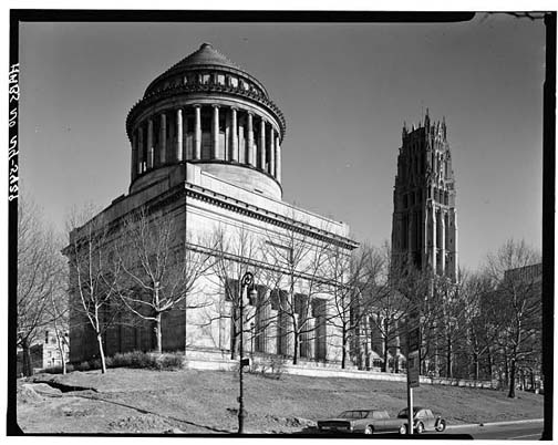
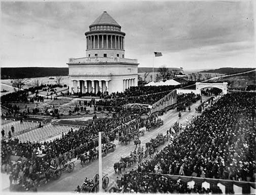
General Grant National Memorial, better known as Grant's Tomb, is considered to be one of America's most imposing memorials. It is a mausoleum containing the bodies of Ulysses S. Grant (1822–1885), American Civil War General and 18th President of the United States, and his wife, Julia Dent Grant (1826–1902). This granite and marble monument is located in Riverside Park, near the intersection of Riverside Drive and W. 122 Street. The plan to build the monument started in 1885 but was only completed 12 years later, for the 75th anniversary ceremony of Grant’s birth on April 27, 1897 (Kahn 1980).


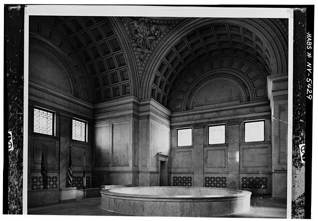
The structure rises 150 feet above the ground and symbolically faces south. It has an eclectic architectural style inspired by different and distant emblematic buildings such as The Mausoleum at Halicarnassus, Napoleon's Tomb in Dome des Invalides, Tropaeum Alpium in La Turbie, and Emperor Hadrian's Tomb in Rome. These influences aimed “to produce a monumental structure that should be unmistakably a tomb of military character (TGMA 2012)”


Grant's Tomb was New York's biggest touristic attraction in the early 1900s. In 1958 the National Park Service was conferred authority to manage the Tomb. However, in the 1970s, the monumentality of the Memorial was reconfigured and it became a meeting point for drug dealers, crack consumers and homeless. Moreover, it and was affected by vandalism and graffiti (Allon 1997).


In 1991, Columbia student Frank Scaturro volunteered with the National Park Service and became an activist for the restoration of the tomb. In 1994, Scaturro’s campaign got the attention of two Illinois state lawmakers who sponsored a resolution to transport the tomb to Illinois in case the NPS did not restore Grant´s tomb. Later on, in the same year, the United States House of Representatives approved legislation to “restore, complete, and preserve in perpetuity the Grant's Tomb National Memorial and surrounding areas”.

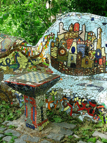
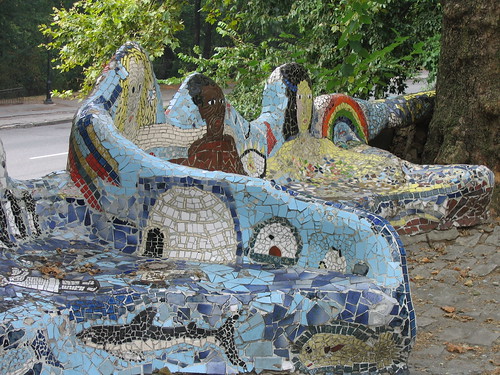
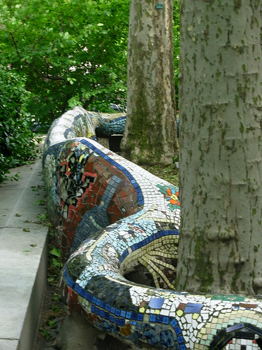
However, a previous effort to stop graffiti and vandalism at Grant's Tomb was made in 1972, when this pretentious mausoleum was exteriorly intervened by the NPS through a public arts project that hoped to by to involve diverse members of the Morningside Heights neighborhood. Between 1972 and 1974, Pedro Silva, a Chilean artist, conducted a team of 2500 local adults and children volunteers that constructed a colorful 350 feet mosaic tile benches that snake around Grant's tomb. The mosaic designs contain obvious Gaudí’s reminiscences, and have been compared to “an unfolding comic book”. They include a portrait of General Grant, depictions of his travels and accomplishments, and other images such as animals, flowers and a New York taxicab.


In 1995 the NPS started a $1.6 million renovation in the monument. The initial project considered removing the mosaics. This action reactivated an old controversy about this artistic intervention in Grant’s tomb. On one side, some Civil War enthusiasts and the NPS considered that the mosaics clashed with the site and trivialize its historical significance and architectural and aesthetic character. Moreover, for the Grant Monument Association the construction of the mosaics took place in the context of a “general decline of patriotism and misdirection on the part of the NPS” and, therefore, they favored their removal.

On the other side, local officials, preservationist and City Arts, a nonprofit group that sponsored the project and other public art projects, considered the mosaics a prominent work of public outdoor art in NY that had become part of the traditional monuments in NYC and, therefore, should be preserved. In this sense, they referred that the monument have had a number of modifications along its history and that the mosaics where only the last moment in this process. Finally, their protests were taken into account and the mosaics removal was stopped and even more, they were recently restored by children and adults from the surrounding neighborhood, again, under the conduction of Silva.


The arguments deployed in this controversy bring central subjects that are still part of the debate about the relations between tradition, change and discipline, and the symbolic and material configuration of landscapes. Grant’s tomb was apparently intended to be a “very dignified mausoleum” (Mindlin 2004) evoking classical styles, but became later a mayor touristic attraction, afterwards a lumpen-park and finally was incorporated into the symbolic universe of the locals through a ludic modification.


This case let us have a very close view on how monuments play a central role in the construction of social memory, and how the struggle for controlling this process can radically transform a particular landscape.


References

Allon, Janet. (1997). “Mosaic Benches Face Unseating At Grant's Tomb”. The New York Times. Published: March 30.

Kahn, David. (1980). General Grant National Memorial Historical Resource Study. NPS

Mindlin, Alex (2004). “Neighborhood Report: Morningside Heights; Dust-Up Over Center For Grant's Tomb”. The New York Times. Published: August 01, 2004

The Grant’s Tomb Monument Association Website. http://www.grantstomb.org/