Tuesday, January 31, 2012

Crossings and Boundaries: Moving through Manhattanville

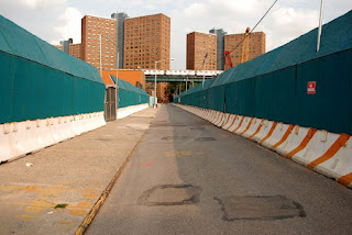
Landscape transformation is ongoing, but can be exacerbated and accelerated by dramatic interventions both natural and human-induced (and of course both or a combination thereof). Such is the current case in Manhattanville, where Columbia University’s expansion project north of 125th Street into West Harlem is intervening daily to produce new spaces that consciously seek to integrate the worlds of the university and its surrounding communities. In 2005, Marilyn Taylor, one of the primary design collaborators on the project, wrote the optimistically titled, “Crossing Beyond the Boundaries: Columbia University in West Harlem.” In it she stated the intentions of the project:

“This twenty-first-century urbanity [of the Manhattanville extension project] is in direct contrast to the twentieth-century version that created the character and “gravitas” of the Morningside campus. The introspection and formality of this classic space created a magnificent presence. But it was one conceived as fundamentally separate from the surrounding city. In Manhattanville, we envision the energy of the city and academy flowing together. We hope this will create a place that is simultaneously “campus” and “not campus”” (Taylor 52).

But the transformation of a landscape (and even more, of the relationships of the people living in it) is obviously not just about the difference between what was before, and what is after. It is not only about the end result of spatial management and integration. It includes elements that are also temporal, active and social. It is about the transformation process itself – in this case, the period of time during which the area is under construction – and the social and political relationships that are produced, suppressed, and negotiated through the experience of living in that change.

Perhaps this is why a quick perusal of news coverage of the project over the past few years does not return many discussions of the final vision, critiques of the proposed design itself, or reflections on its historical comparability to the existing campus. Instead, and indeed somewhat predictably, I found criticisms of the intrusion of construction on daily lives, of enforced displacements, and of the shortcomings of administrative responses to these concerns that typically took “big picture” views. Furthermore, the complaints I read are not, as one might expect, primarily about the visual unpleasantness of waking up to a skyline of cranes, or walking past giant sinkholes. Instead, the complaints draw attention to other ways of knowing and living in an urban construction zone that emphasize its multi-sensory and multi-elemental nature – aspects of life that are not apparent in pristine urban design drawings and mock-ups, or from aerial views of that remove one bodily from the scene.In attempting to break down aesthetic boundaries as seen from outside and above, the project may well be re-inscribing numerous emotional and psychological ones.


I give two examples of affected non-visual aspects of the landscape here.

First, in the rush to examine the construction areas themselves, one might easily miss the very space that allows their examination: the streets.

You can find a list of planned closures and restrictions to streets (and consequently, movement through them) here. The list is not short, or uncomplicated. It requires one to consider the complex and often subconscious ways in which movement through a changing landscape reinforces one’s relationship to it, and how enforced changes to that relationship recreate power struggles and inequalities that are re-experienced every day.

Henri Lefebvre wrote that “Power seeks to control space in its entirety, so it maintains it in a ‘disjointed unity,’ as at once fragmentary and homogenous: it divides and rules” (Lefebvre 388).

What more effective way to divide and homogenize than to close and alter roadways? Streets are the spaces that allow movement from one place to another, that bring people together through and across a landscape, even as they emphasize the distinction between being in one place or another. When they are closed, all of the daily activities of life – businesses, commutes, leisurely strolls, shopping excursions – must be subordinated to the ends of the project. To close a road while subsuming the area around it into the university’s domain seems the ultimate example of Lefebvre’s observation.

The second example comes from an intended response to the first. As stated on the page linked above, New York City does not allow work on intersections during daylight hours, presumably to minimalize the spatial impact discussed (as well as, in all likelihood, for its own convenience, as the traffic from backed-up intersections would be much more difficult to manage and re-route). This means that as of February 13, work at the intersection of W 125th St and 12th Ave will take place between the hours of 10:00 pm and 5:00 am.

I quote, “This will include some noisy work.” This is clearly a problematic logistics issue, and I can imagine that once the decision to do work is taken, the scheduling of relative inconveniences is difficult. However, it does provoke consideration of the choice, a joint maneuver of city and developers, in the overall context of the project. Night construction provides yet another way in which the activity of transformation invades and re-structures local lives; noise pollution is always part of city living, and noise always refuses to stay outside, pushes itself past other physical boundaries and makes itself known wherever it finds itself. However, now this noise will not be confined even to daylight hours, when one expects to encounter the greater part of the rest of city noise. Yet another boundary is disregarded, and therefore thrown into high relief.

I conclude with another quote from Taylor, who writes that with the accomplishment of the expansion project, “The boundaries between the academy and the workplace will become less defined. So too will the distance between the city and the academy diminish. This will create a new urbanity, energized by learning, characterized by interaction” (Taylor 53). I cannot help wondering who is identifying the boundaries to be (un)defined, and the distances to be diminished, and to whose advantage the closing of this landscape might be.

Photo credits: Nathan Kensinger – more photos of the demolition can be seen here: http://kensinger.blogspot.com/2011/08/demolition-of-manhattanville.html

Drawing credits: Skidmore, Owings & Merrill with Renzo Piano Building Workshop

Cited works:

Lefebvre, Henri, 1974. The Production of Space. Donald Nicholson-Smith (Transl). Malden, MA: Blackwell Publishing Edition, 2011.

Taylor, Marilyn, 2005. “Crossing Beyond the Boundaries: Columbia University in West Harlem.” Places 17:1

Views from Columbia's Campus

Slowly Broadway -- the old main thoroughfare of the New Netherland colony to the City -- rises up along the hilly backbone of Manhattan toward Columbia University's campus (and then onward). Nowadays, walking along Broadway, the elevation is barely noticeable in the man-made canyons of New York City; so many of the original natural landscape features have been erased in this City..


The current Columbia campus is a bit like a castle, a prison, or an oasis, depending on your mood. A series of high buildings  surround and enclose a space that is open, sometimes green, sometimes claustrophobic. A fortress from the outside.


Depending on one's approach to the Campus, this castle-like quality of the campus may not be the first thing one notices. The Campus' entrance is in fact quite open: high open gates and trees welcome the visitor. In New York City, high imposing walls of buildings are nothing new and so are easily filtered out. Coming to this open space, one becomes aware that one has indeed reached the Columbia Campus. The University announces it presence. The visitor sees before her a straight path -- the College Walk -- leading straight into the clouds.


Following the path one comes to a great open plaza, where the highest point is taken up by a building marked "The Library of Columbia University". Although ironically this building now houses the university's administration, which looks down from its high point on the current main library  -- Butler Library -- on the other side of the main square. A cynic may say that Power goes over Knowledge here.


It should be noted that the point taken up by Low Library may not be the highest point in Manhattan as a whole (it is in fact in Bennett Park), but it is clearly one of the highest points on the island and certainly in the neighbourhood. The elevation of the point is only accentuated by the steep decline into the valley that has its lowest point around 125th Street. However, none of this is clear when gazing upon Low Library from College Walk, or even walking around Campus. As I said, the Campus shields off most of the city with its wall of high buildings. From the campus grounds there are only a few cracks in the wall; one instance being between the Schermerhorn and Fayerweather buildings.


Apart from this little alcove and the view from College Walk, there is another point where Columbia's elevated position in the city is made clear and this is at the The Charles Revson Plaza, that strange space that hoveres over Amsterdam Avenue in front of the Law School.


If it wasn't already, a strange eye-like statue makes clear what this place is about: looking out over the city -- on either side. Even though, the view toward the north (into the 125th Street valley) may be more spectacular, in fact the eye looks toward the south, toward the city, gazing down.


In conclusion, the campus of Columbia University appears to provide only two views: 1) as an enclosed space, buildings keeping the outside world out. Or 2) it provides vistas from above, such as Revson Plaza and College Walk. The campus appears to say: we are not really in New York City, we are in the sky! When we are on campus, we are sky-(wo)men, indeed: god-like - like De Certeau looking down on Downtown Manhattan, Wordsworth gazing on his favourite valleys, or Dante reaching heaven.

Monday, January 30, 2012

Invisible City


Over the course of three days, scientists pumped 10 tons of concrete into an ant hill.  After letting it set, the colony was excavated, revealing a structure of staggering complexity covering 50 square meters and running 8 meters deep.  In creating this archaeological site and revealing this unimagined landscape, one may assume that a large instance of ant genocide was committed in the name of scientific knowledge, but the extraordinary results trump countless formic murders.
The ants who built this particular colony moved out 40 tons of earth in the process of construction, with each worker carrying three times his own weight in soil on each trip. According to the video, it is the ant equivalent of building the Great Wall.

What was revealed is astounding.  A vast complex city-state with tubular roads and air vents and bulbous extensions, it looks space age in the contained environment manner of Charles De Gaul International airport with its connected travel tubes and pods.  It calls to mind Frank Herbert’s Dune with its underground drug mining society and giant worms.  These are the Invisible Cities that Italo Calvino didn’t write about. 

That there are such states below our feet, and that they are far more complex than the architectural and structural archaeological remains of many human sites, inspires awe.  The Maya inscribed their sculptures on their bottoms, acknowledging the gods beneath the surface, the divinity of earth.  As archaeologists, we are drawn to the hidden; we must remember to be open to that which we least expect.

http://www.youtube.com/watch?v=lFg21x2sj-M

Monday, January 23, 2012

Geology Among Us

I walk by a boulder countless times a week on my way to and from my building on 114th and Riverside. Couched between the back of a Cuban restaurant and an apartment building, this huge chunk of rock rests innocuously behind a gated fence blocking the restaurant's storage entrance from the street. Many people walking by don't even register its presence; the iron fence obscures the rock's dark face. Two stories tall and 100 feet wide, the rock takes up what must be valuable Morningside Heights real estate.

Looking at photographs of the neighborhood from a century ago, there was much more open space to be developed. Hundreds of similar rocks must have been blasted to make way for the construction of the crowded blocks of today's New York, but for some reason this one was overlooked. According to a New York Times article, the rock was simply never removed in the course of the neighborhood's development. "'When the row houses were built around it in 1896, leaving the rock was no big deal because there were hundreds of acres to develop,'' said William Scott, vice president for institutional real estate at Columbia. 'But now, it's just this huge ugly rock in the middle of our neighborhood.'"

It serves as a reminder of what Manhattan looked like before we drastically altered its appearance. I mean no judgment in that statement, but I appreciate the two senses of the city evoked by the sight of the rock.

On one hand, Manhattan is defined by its city blocks, myriad stores and residences, and strictly delineated property lines. The rock on 114th is tamed by its iron fence, and made mundane by the stacks of beer kegs and trash cans lining its eastern side. On the other hand, this rock clearly renders unusable one of the most cherished commodities in the city - space. It reminds us that the nature that we cordon off in city parks was once all that Manhattan consisted of. Millions of years of geological time seep into our everyday experiences of New York. The city before human occupation is not gone, just buried under concrete in most places. But sites where its earlier form remains, like with this rock on 114th st., are not static reminders of the past. A tree grows out of one crack in the rock's street-facing surface, oblivious to the lack of greenery around it.

On a larger scale, it appears that every part of the city was intentionally placed, but when experienced on a day-to-day level each neighborhood and street reveals idiosyncrasies that fell through the cracks of urban planning. Walking by that boulder every day gives me a little twinge of delight, like I'm experiencing the land's response to human occupation.

Images from: The Fed, The Harlem Eye, Columbia College

Further information: NYTimes, The Fed

Thursday, January 19, 2012

Occupy Wall Street Archaeology

A number of Columbia University archaeologists and anthropologists have created a small-scale archaeological project at Occupy Wall Street.

We have created a weblog, where we will post about our findings. Furthermore, we are inviting abstracts for our session at the upcoming TAG-USA (Theoretical Archaeology Group) conference, in Buffalo, NY, May 17-20, 2012.

 (serving spoon in a storm drain at Zuccotti Park on morning after the eviction, Nov 15, 2011)

Tuesday, January 10, 2012

Moon Archaeology

Image from New York Times

Great to see that people are starting to think about archaeology on the moon. Greg Fewer wrote a paper about this a few years ago, in a book called Digging Holes in Popular Culture, edited by Miles Russell. His paper is 'Towards a Lunar and Martian Sites and Monuments Record'